
The CSHORE numerical model is a robust and efficient model that predicts nearshore hydrodynamics and beach evolution. Designed for rapid application to cross-shore transects, computation times including nearshore morphology are typically 10 −5 of the modeled time duration. The combined wave and current model operates under the assumption of longshore uniformity and includes the effects of a wave roller and quadratic bottom shear stress. The numerical integration of the depth-averaged energy, momentum, and continuity equations manifests with predictions of wave height, water level, wave-induced steady currents, and wave runup excursion. The development of new and physically defensible sediment transport algorithms for a nearshore breaking wave environment has been the focus of the most recent research efforts. The model accounts for wave and current interaction, bedload, suspended load, and wave-related sediment transport. In a departure from conventional models that directly or indirectly relate transport to bottom shear, the CSHORE model relates suspended sediment volume with energy dissipation due to breaking and bottom boundary shear. Likewise, the bedload expression has an inherent dependence on the energy dissipation for a wave-dominated nearshore environment and includes the important wave-generated flux that is directed with the wave propagation vector. A full treatment of the theoretical underpinnings of CSHORE are available in Johnson et al. 2012.

Key features of CSHORE:
- Suitable for application in nearshore environment
- Efficient and stable numerical performance
- Limited to use on coasts of gradual longshore variation
- Provides phase-averaged predictions of wave characteristics and steady hydrodynamics
- Computation of wave overtopping
- Predicts runup statistics including impact of wave setup and wind-wave contribution
- Sand transport estimates are based on wave and bottom shear dissipation
- Morphological evolution is computed over hours or days
Keywords:
CSHORE, nearshore, swash, runup, storm surge, beach profile, profile evolution.
USACE Point of Contact:
Brad Johnson Bradley.D.Johnson@usace.army.mil
The source code and execuables for the CSHORE mode is freely available at
https://github.com/erdc/cshore
where precompiled binaries are availbel for both Windows and Linux operating environments.
Recent USACE Reports
- D.L. Young, A.S. Bak, B.D. Johnson. “Initialization and Setup of the Coastal Model Test Bed: CSHORE “ ERDC/CHL CHETN-IV-115. https://apps.dtic.mil/sti/pdfs/AD1069565.pdf
- D.R. Krafft, B.C. McFall, J.A. Melby, and B.D. Johnson “Estimating Nearshore Nourishment Impact on Subaerial Beach Nourishment Lifespan in StormSim.” ERDC CHETN (Submitted June 2022).
- B.D. Johnson and D.Sanderson ‘’On the Use of CSHORE for Beach-fx’’ ERDC/CHL CHETN-II-59. https://apps.dtic.mil/sti/pdfs/AD1107118.pdf
Recent Journal Publications
- N. Cohn, K. Brodie, B. Johnson, and M. Palmsten. ‘’Hotpsot Dune Erosion on an Intermediate Beach.’’ Coastal Engineering 170, (2021) 103998. https://doi.org/10.1016/j.coastaleng.2021.103998
- L. Zhu, Q. Chen, Y. Ding, N. Jarafi, H. Wang, and B. Johnson, “Universal relation of drag coefficient for quantifying wave energy reduction by salt marshes.” Coastal Engineering 180 (2023) 104256. https://doi.org/10.1016/j.coastaleng.2022.104256
Test cases, including model setup scripts, input files, measured comparison data, and plotting routines are available at https://github.com/erdc/cshore/tree/master/usace_distribute_bundle/testbed
CSHORE LSTF
- Test 1 Case 3
Comparison data are provided for cross-shore distribution of wave
height, longshore current, and longshore sand transport.LSTF
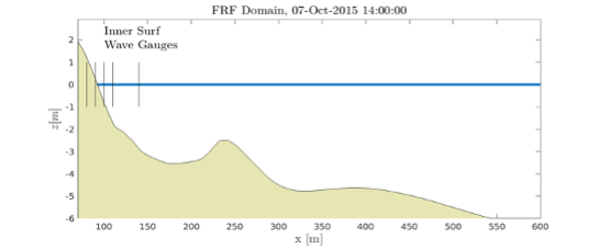
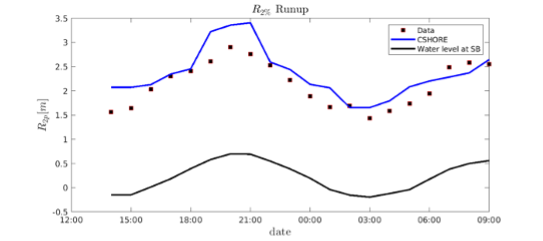
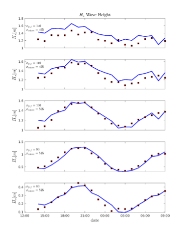
CSHORE FRF Bathyduck
Two tests are provided with date ranges:
30-Sep-2015 14:00:00 to 01-Oct-2015 10:00:00
07-Oct-2015 14:00:00 to 08-Oct-2015 10:00:00
Comparison data are provided for inner surf wave height and runup.
CSHORE FRF morphological change
Two tests are provided with date ranges:
03-Oct-2016 18:15:00 to 20-Oct-2016 18:15:00
20-Oct-2016 18:15:00 to 03-Nov-2016 18:15:00
Comparison data are provided for bottom position change.
- CSHORE OSU Great Erosion Experiment morphological change
One test is provided with 40 hours of forcing conditions.
Comparison data are provided for bottom position taken at 45 times throughout test.
Revisions are all available on the previously provided github page. The CSHORE model assumes that dune overtopping is limited to intermittent wave overtopping. This precludes having conditions where the seaward boundary water level is higher than the maximum profile position.